

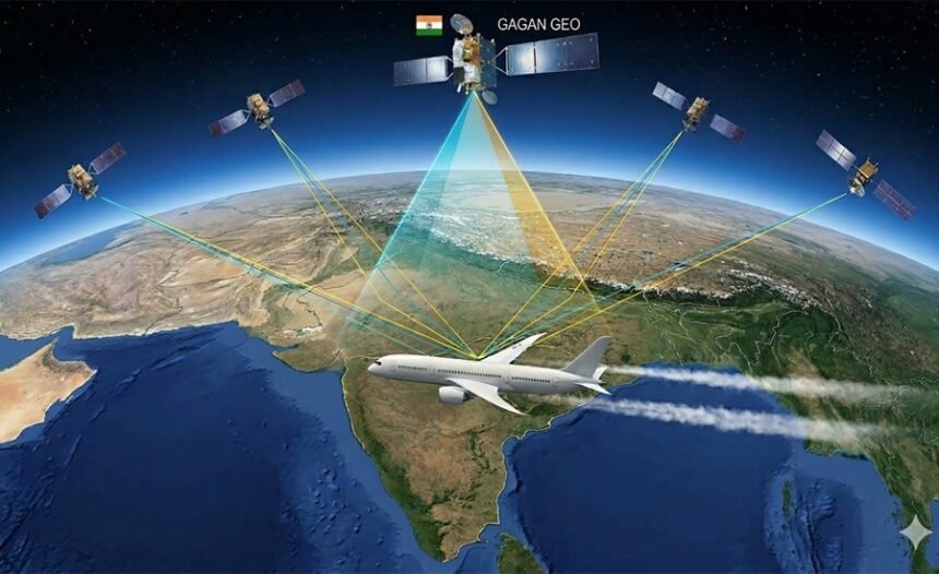
GAGAN aka GPS Aided GEO Augmented Navigation was jointly developed by ISRO and the Airports Authority of India, and it puts India in a group that currently includes the United States, Europe and Japan. The system enhances GPS accuracy by providing real-time corrections and integrity information, making aircraft navigation safer and precision landings more reliable. Built to international aviation standards from the outset, GAGAN has since found applications well beyond civil aviation in disaster management, defence, transport and geospatial work feeding into the broader Aatmanirbhar Bharat push for technological self-reliance.
Why GPS alone isn’t enough, and what GAGAN does about it
Aircraft depend on GPS for navigation, but GPS signals are vulnerable to atmospheric disturbances and other sources of error that affect positioning accuracy. In most situations, those errors are manageable. During approach and landing operations, they aren’t even small inaccuracies matter when an aircraft is descending toward a runway.
GAGAN was built to address exactly this. Rather than replacing GPS, the system continuously monitors GPS signals through a network of ground stations, calculates corrections in real time, and broadcasts enhanced positioning data along with integrity information. That last part is worth understanding clearly: the integrity function means that whenever GPS signals become unsuitable for safe navigation, pilots are alerted immediately. It’s not just about making GPS more accurate, it’s about making sure pilots know when they can’t trust it.
A significant milestone came in June 2026, when the Directorate General of Civil Aviation conducted India’s first satellite-based landing system approach on a commercial jet aircraft using GAGAN. It was a practical demonstration of what the system can do, and it confirmed GAGAN’s capability to support precision approaches on commercial aircraft, not just in controlled test conditions.
The infrastructure behind it
GAGAN operates through an integrated architecture of ground stations, communication systems and geostationary satellites working together continuously.
The ground segment consists of 15 Indian Reference Stations, known as INRES, which monitor GPS signals and detect errors; 2 Indian Master Control Centres, or INMCC, which process that data, calculate signal corrections and generate integrity information; and 3 Indian Land Uplink Stations, INLUS, which transmit the corrected navigation information up to the satellites. Four separate communication networks handle secure real-time data transmission across the system.
In space, three geostationary satellites: GSAT-8, GSAT-10 and GSAT-15, carry GAGAN payloads and broadcast the enhanced navigation signals across the service region. Because geostationary satellites remain fixed relative to the Earth’s surface, the correction information goes out continuously over the same coverage area without interruption.
GAGAN and NavIC
GAGAN sits within a larger indigenous navigation ecosystem alongside NavIC (Navigation with Indian Constellation). The two serve different but complementary functions.
NavIC is an independent regional navigation satellite system. It provides positioning, navigation and timing services across India and up to 1,500 km beyond its borders, operating on its own without relying on GPS. GAGAN, by contrast, works alongside GPS improving its performance by supplying correction and integrity information tailored specifically for aviation use. One provides standalone capability; the other makes an existing global system more reliable and trustworthy for safety-critical applications.
Together, the two systems reduce India’s dependence on foreign navigation infrastructure in a meaningful way. India is also working to extend NavIC’s international footprint. In 2025, it signed an agreement with South Africa to establish a NavIC reference station, a step that both extends the system’s geographic reach and signals growing international interest in India’s navigation technologies.
Where GAGAN stands globally
GAGAN has been developed fully in line with international civil aviation standards and is interoperable with the major satellite augmentation systems operating elsewhere. These include the Wide Area Augmentation System of the United States, the European Geostationary Navigation Overlay Service, and Japan’s Multi-functional Satellite Augmentation System. International aircraft equipped with compatible receivers can use GAGAN while operating within Indian airspace, which strengthens both aviation safety and regional connectivity.
One distinction worth noting: GAGAN is the first Satellite-Based Augmentation System certified specifically for the equatorial region. Developing an SBAS that functions reliably near the equator where ionospheric disturbances are more pronounced and harder to model is technically more demanding than doing so at higher latitudes. That certification places India in a genuinely rare company.
Uses that go well beyond the runway
GAGAN was designed for aviation, but high-precision positioning has value in many other sectors, and the system’s applications have expanded accordingly.
In maritime navigation, it supports safer operations along India’s coastline and in offshore areas. In road transport, it feeds into intelligent transport systems and fleet management. Railway operations have also begun drawing on GAGAN for improved safety and efficiency. During disasters and emergencies, accurate location tracking matters enormously, and GAGAN supports that capability. Defence and national security applications use the system’s reliable positioning. Telecommunications networks that require precise synchronisation benefit from it. And in surveying, mapping and geospatial data collection, the higher positional accuracy GAGAN provides translates directly into better output.
The breadth of these applications reflects something important about what an operational SBAS actually represents it’s not a single-use system. Once the infrastructure exists and the signals are being broadcast, the precision it offers becomes available to any sector that needs it.
What comes next
GAGAN’s role in India’s navigation landscape is expected to grow. Alongside NavIC, it will continue supporting safer air navigation, modern air traffic management and satellite-based precision approaches while reducing the country’s reliance on foreign systems. The June 2026 precision approach demonstration suggests that more routine use of GAGAN for commercial landings is on the horizon.
Wider adoption across transportation, telecommunications, disaster response, defence and geospatial services is already happening, and that trajectory is likely to continue. As India’s digital and physical infrastructure becomes more interconnected, a reliable, homegrown, internationally certified navigation system stops being a technical achievement and starts being a foundational layer that other systems depend on. That’s the position GAGAN is moving toward.
Key takeaway: GAGAN has put India among a small group of countries with a certified, operational Satellite-Based Augmentation System, one built to international standards and interoperable with systems in the US, Europe and Japan. Its primary role in aviation safety is well established, and the June 2026 precision approach milestone showed what that means in practice. Beyond aviation, its applications across transport, defence, disaster management and geospatial services are growing. Together with NavIC, GAGAN is becoming a foundational part of India’s navigation infrastructure rather than a standalone technical achievement.
MCQ:
Question 1:
GAGAN is:
A. India’s regional navigation satellite constellation
B. India’s Satellite-Based Augmentation System (SBAS)
C. India’s military communication satellite network
D. India’s air traffic control software platform
Question 2:
GAGAN was developed jointly by:
A. ISRO and DRDO
B. ISRO and DGCA
C. ISRO and Airports Authority of India
D. ISRO and IN-SPACe