
The Government of India is putting satellite and geospatial technology to work in Ladakh, using it to keep tabs on glaciers, glacial lakes, snowfall, water resources, and landslides across the region. Here’s a closer look at what that work involves.
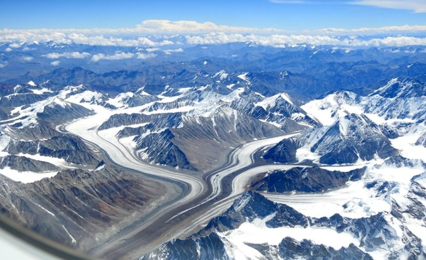
On the glacier front, a database covering more than 2,000 glaciers in Ladakh has been built using satellite data gathered between 2020 and 2023. As part of this effort, changes in the extent of over 1,000 of these glaciers have been mapped across a span of more than two decades.
Tracking Glacial Lakes, Snow Cover, and Wetlands
Glacial lakes have gotten similar attention. Under the Ministry of Jal Shakti’s National Hydrology Project, an inventory of 3,219 glacial lakes larger than 0.25 hectares has been compiled for Ladakh. High-risk lakes, including Katkar and Suru, have also been put through Glacial Lake Outburst Flood (GLOF) risk modelling.
Snow cover across the Indian Himalaya, Ladakh included, has been mapped daily using satellite data from 2019 right up to September 2025. Meanwhile, in partnership with the University of Jammu, 4,912 wetlands across Ladakh have been mapped. And roughly 41 waterbodies larger than 5.0 hectares are being tracked and kept updated through satellite data, with this information made publicly available on the Bhuvan Waterbody Information System since 2012. On the landslide side, ISRO continues to use satellite data to periodically refresh Ladakh’s landslide inventory.
Major Satellite-Based Projects of the Last Five Years
A number of dedicated projects have taken shape in Ladakh over the past five years. The Cryosphere Science and Applications Programme (CAP) is an ongoing ISRO initiative that monitors snow and glaciers across the Himalaya-Karakoram region, including Ladakh, working alongside state agencies, academic institutions, and research bodies.
Ladakh Specific Modelling and Space Applications (LAMA) is a project being run by ISRO/DoS specifically for the Union Territory, and it covers developing a weather forecasting model built on space-based inputs, issuing heavy rainfall alerts, and running hydrological simulations to estimate snow melt, glacial melt runoff, and river discharge.
The Satellite Integrated Landslide Assessment and Alert System (SILAAS), run under ISRO-DMSP, has been active since 2023, mapping landslides in Ladakh using satellite data and generating village-wise landslide alerts.
Hydrology, Geospatial Infrastructure, and Ongoing Research
The National Hydrology Project ran from 2017 to 2025, sponsored by the Ministry of Jal Shakti’s Department of Water Resources, River Development and Ganga Rejuvenation. It covered glacial lakes mapping, GLOF risk assessment, snow-cover monitoring, evapotranspiration studies, and hydrological drought assessment.
Then there’s Geo-Ladakh, formally the “Spatial Data Infrastructure (SDI) Geoportal with Allied Database Development for UT-Ladakh” project, carried out by ISRO to build the Geo-Ladakh geoportal and generate a geospatial database covering natural resources, energy, infrastructure, and administrative boundaries, alongside capacity-building efforts.
ISRO/DoS is also engaged in advanced R&D work aimed at strengthening space-based early warning systems for GLOF events, extreme weather, and landslides, research whose outcomes are expected to benefit Ladakh as well.
Supporting Disaster Response and Long-Term Planning
When major disasters strike, ISRO/DoS supplies Ladakh UT with space-based information on floods, GLOF events, and forest fires during the response phase. Separately, under the Space-based Information Support for Decentralised Planning (SISDP) initiative, ISRO/DoS has mapped Land Use/Land Cover, drainage, settlements, slope, and rail and road infrastructure at a 1:10,000 scale, all hosted on the Bhuvan-Panchayat portal to support development planning.
As part of its broader push to expand the use of space technology for sustainable development and disaster risk reduction, ISRO/DoS also runs periodic training programmes, and participants from Ladakh have taken part in and benefited from these sessions.
This information was shared by Dr. Jitendra Singh, Union Minister of State for the Prime Minister’s Office and for Personnel, Public Grievances and Pensions, Atomic Energy and Space, in a written reply in the Lok Sabha.
Key Takeaway: The Government of India is increasingly integrating space-based technologies into disaster management and environmental monitoring in Ladakh through satellite mapping, geospatial databases, and predictive modelling of glaciers, glacial lakes, snow cover, landslides, water resources, and extreme weather. Initiatives such as the Cryosphere Science and Applications Programme (CAP), Ladakh Specific Modelling and Space Applications (LAMA), SILAAS, Geo-Ladakh, the National Hydrology Project, and the SISDP programme demonstrate a comprehensive approach that combines scientific research, early warning systems, disaster response, and development planning.
Together, these efforts strengthen Ladakh’s resilience to climate- and terrain-related hazards while showcasing the expanding role of ISRO and space technology in disaster risk reduction, resource management, and sustainable regional development.
M.C.Q.
Question 1: With reference to Glacial Lake Outburst Flood (GLOF), consider the following statements:
- It occurs when a glacial lake suddenly releases a large volume of water.
- GLOFs are a major natural hazard in the Himalayan region.
- Satellite-based monitoring is used to identify potentially hazardous glacial lakes.
Which of the statements given above is/are correct?
- A. 1 only
- B. 1 and 2 only
- C. 2 and 3 only
- D. 1, 2 and 3
Question 2: The Bhuvan platform developed by ISRO is primarily used for:
- A. Satellite navigation for commercial aviation.
- B. Geospatial data visualization, mapping, and planning applications.
- C. Launching weather satellites into orbit.
- D. Providing internet connectivity to remote villages.
Read More: Public Examinations Bill 2026: A Strong Statement & New, Costly Penalties